If you can't be a pine on the top of the hill
Be a scrub in the valley
but be the best little scrub by the side of the hill,
Be a bush
if you can't be a tree.
If you can't be a highway
just be a trail
If you can't be the sun
be a star;
It isn't by size that you win or fail...
Be the best of whatever you are.
Italian translation...
Se non puoi essere un pino sul monte,
sii una saggina nella valle,
ma sii la migliore piccola saggina sulla sponda del ruscello.
Se non puoi essere un albero,
sii un cespuglio.
Se non puoi essere un'autostrada
sii un sentiero.
Se non puoi essere il sole,
sii una stella.
Sii sempre il meglio di ciò che sei.
Martin Luther King
Tuesday, August 19, 2008

Friday, July 25, 2008
Back again after 3 moths...
I am back again with some JGrass tips.
Things have been really busy in this period, I think the only week I wasn't in office was the Hacking Event in Bolsena, thanks to all partecipant for the nice days.
Regarding the JGrass staff, yeah we are working on it, and we are planning to finish all the porting from the old JGrass2.0 to the new JGrass uDig plugin. So during the next month I will write some documentation (here or in the wiki) on JGrass main stuffs. The month before FOSS4G is financed by HydroloGIS and CUDAM to set up all the needed user documentation and to fix some of the known (and unknown but coming) JGrass bugs/problems/not so usable things.
If you use JGrass and have some interesting comments, please leave your comment here or use the JGrass wiki page to directly interact with our staff.
All the problems and bug reports are very wellcome.
Things have been really busy in this period, I think the only week I wasn't in office was the Hacking Event in Bolsena, thanks to all partecipant for the nice days.
Regarding the JGrass staff, yeah we are working on it, and we are planning to finish all the porting from the old JGrass2.0 to the new JGrass uDig plugin. So during the next month I will write some documentation (here or in the wiki) on JGrass main stuffs. The month before FOSS4G is financed by HydroloGIS and CUDAM to set up all the needed user documentation and to fix some of the known (and unknown but coming) JGrass bugs/problems/not so usable things.
If you use JGrass and have some interesting comments, please leave your comment here or use the JGrass wiki page to directly interact with our staff.
All the problems and bug reports are very wellcome.
Wednesday, April 23, 2008
How print two-sides brochure in OpenOffice
To save paper and ink when printing I love to have my documents printed with two pages in one and on both sides. Finally I found these two helpfull links to make it automatically in OpenOffice...
http://openoffice.blogs.com/openoffice/2008/03/printing-two-si.html
http://blog.dixo.net/2007/07/18/save-paper-with-openoffice-brochure-printing/
Enjoy your printing!!! :-)
Tuesday, April 22, 2008
A tribute from my hydrologic menthor
From opera "i mille fiumi" (the thousand rivers) of Arrigo Boetti and Anna-marie Sauzeau-Boetti
La classificazione per ordine di grandezza e' il metodo più comune per organizzare l'informazione relativa ad una data categoria, nel caso dei fiumi, la grandezza si puo' intendere alla potrenza uno, due, o tre., cioè può essere espressa in km, km2 o m3 (lunghezza, bacino o portata), il criterio di lunghezza e' il più arbitrario e ingenuo, ma tutt'ora il piu' diffuso, eppure e' impossibile misurare la lunghezza di un fiume per le mille e piu' perplessita' che solleva la sua esistenza fluida (per i suoi meandri e i suoi passaggi attraverso i laghi, per le sue diramazioni attorno alle isole o i suoi spostamenti nella zona del delta,, per gli interventi dell'uomo lungo il suo corso, per i confini inafferrabili tra acqua dolce e acqua salata ...) molti fiumi non sono mai stati misurati perche' le loro rive o acque sono inacessibili, persino gli spiriti dell'acqua solidarizzano a volte con la flora e fauna per tenere gli uomini a distanza, di conseguenza alcuni fiumi scorrono senza nomi, innominati per la loro realta' intoccata, o innominabili per scongiura umana (alcuni mesi fa, un pilota che volava a bassa quota sopra la foresta brasiliana scopri' un "nuovo" affluente del rio delle amazzoni). altri fiumi non possono essere misurati perche' invece hanno un nome, un nome causale dato loro dagli uomini (nome uniforme lungo il corso intero quando il fiume, navigabile diventa veicolo di comunicazione umana; nomi diversi quando il fiume, temibile, visita gruppo umani isolati); ora l'entita' di un fiume si puo' stabilire o in riferimento al suo nome (traccia dell'avventura umana), o in riferimento alla sua integalita' idrografica (avventura dell'acqua dal punto sorgente piu' remoto fino al mare, l di fuori dei nomi assegnati ai vari tratti), il problema e' che le due avventure coincidono raramente, di solito l'avventura dell'esploratore va contro corrente, partendo dal mare; quella dell'acqua invece ci finisce, l'esploratore che risale il fiume deve fare testa o croce ad ogni bivio, perche' a monte di ogni confluenza tutto si rarefa: l'acqua, a volte l'aria, ma sempre la propria certezza, mentre il fiume che scende verso il mare condensa gradualmente le sue acque e la certezza della sua strada ineluttabile, chi puo' dire di se e' meglio seguire l'uomo o l'acqua? l'acqua, dicono i moderni geografi, obiettivi e umili, e cosi' si mettono a ricomporre l'identita' dei fiumi, un esempio: il mississipi di neworleans non e' proprio l'estensione del mississipi che sorge dal lago itasca nel minnesota, come s'impara a scuola, ma di un ruscello che sorge nel montana occidentale sotto il nome di jefferson red rock e poi diventa mississipi-missouri a st louis, il numero di chilometri a monte risulta maggiore dalla parte del missouri, pero' e' un fatto che questo metodo "scientifico" viene attuato soltanto a proposito dei grandi fiumi prestigiosi, quelli suscettibili di gareggiare per primati di lunghezza, il ripensamento metodologico non si spreca per i minori (meno di 800 km) i quali continuano a chiamarsi (e misurarsi) secondo il solo nome di battesimo, anche se, nel caso che abbiano due corsi sorgenti (dotati di altri due nomi) quello piu' lungo potrebbe essere giustamente incluso nel corso principale, la presente classificazione rispecchia questo doppio metodo, esso segue la legge dell'acqua e la legge degli uomini, perche' tale si presenta l'informazione a riguardo, in breve, rispecchia il gioco parziale dell'informazione piu' che la vita fluida dell'acqua, questa classificazione fu iniziata nel 1970 e terminata nel 1973, alcuni dati furono trascritti da pubblicazioni famose, numerosi dati furono elaborati sulla materia fornita dagli istituti geografici non europei, governi, universita', centridi studi privati e singoli studiosi di tutto il mondo, questa convergenza di documentazione costituisce la sostanza e il significato del lavoro, gli innumerevoli asterischi contenuti in queste mille schede pongono innmerevoli dubbi e fanno da contrappunto al rigido metodo di classificazione, sia l'informazione parziale esistente sui fiumi, sia i problemi linguistici legati alla loro identita', sia la natura irrimediabilmente sfuggente delle acque, fanno che questa classifica come tutte le precedenti o successive sara' sempre provvisoria e illusoria
Anne-marie Sauzeau-Boetti
(n.d.t the text is published without capital letters)
Unfortunatelly I didn't find an English version of the text... maybe someone has one.
Unfortunatelly I didn't find an English version of the text... maybe someone has one.
Saturday, April 5, 2008
Which values?
I will put here a lyric I read on an Environmental Declaration of an Italian institution. It is in Italian, I don't want to translate it but if someone will ask I will try... not so easy for my poor English... :-)
From the "Opera sull'acqua e altre poesie" of Erri De Luca 2002, a collection of lyrics having the theme the water, the first one...
VALORE
Considero valore ogni forma di vita,
la neve, la fragola, la mosca.
Considero valore il regno minerale,
l'assemblea delle stelle.
Considero valore il vino
finché dura il pasto,
un sorriso involontario,
la stanchezza di chi non si è risparmiato,
due vecchi che si amano.
Considero valore quello che domani non varrà più niente
e quello che oggi vale ancora poco.
Considero valore tutte le ferite.
Considero valore risparmiare acqua,
riparare un paio di scarpe,
tacere in tempo,
accorrere a un grido,
chiedere permesso prima di sedersi,
provare gratitudine senza ricordare di che.
Considero valore sapere in una stanza dov'è il nord,
qual è il nome del vento che sta asciugando il bucato.
Considero valore il viaggio del vagabondo,
la clausura della monaca,
la pazienza del condannato, qualunque colpa sia.
Considero valore l'uso del verbo amare e l'ipotesi che esista un creatore.
Molti di questi valori non ho conosciuto.
I consider a value to save water...
From the "Opera sull'acqua e altre poesie" of Erri De Luca 2002, a collection of lyrics having the theme the water, the first one...
VALORE
Considero valore ogni forma di vita,
la neve, la fragola, la mosca.
Considero valore il regno minerale,
l'assemblea delle stelle.
Considero valore il vino
finché dura il pasto,
un sorriso involontario,
la stanchezza di chi non si è risparmiato,
due vecchi che si amano.
Considero valore quello che domani non varrà più niente
e quello che oggi vale ancora poco.
Considero valore tutte le ferite.
Considero valore risparmiare acqua,
riparare un paio di scarpe,
tacere in tempo,
accorrere a un grido,
chiedere permesso prima di sedersi,
provare gratitudine senza ricordare di che.
Considero valore sapere in una stanza dov'è il nord,
qual è il nome del vento che sta asciugando il bucato.
Considero valore il viaggio del vagabondo,
la clausura della monaca,
la pazienza del condannato, qualunque colpa sia.
Considero valore l'uso del verbo amare e l'ipotesi che esista un creatore.
Molti di questi valori non ho conosciuto.
I consider a value to save water...
Friday, April 4, 2008
How to send an error log
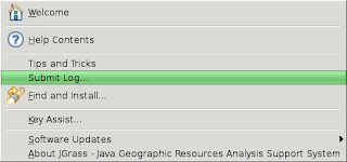
For those that have problems in the JGrass executing and for which for some reason the mailing lists are not enough it is possible to send the error log via email.
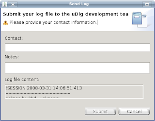
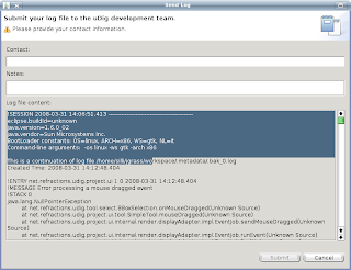
The procedure is the following.
Think that it will be enough, please do not send errors log without before trying to solve the problem via mailing list.
The procedure is the following.
- Help menu and there Submit Log..

- at this point you a new window will appear like the one below

- please do not complete the interface, just enlarge it (just wait when enlarge, it could use a little time to reshape all the window and the content), select all the content of the section "Log file content", copy the content and past it in a new file or email and send it to us

Think that it will be enough, please do not send errors log without before trying to solve the problem via mailing list.
Friday, March 28, 2008
How to set console environment in JGrass (Update1)
Following JGrass development some of you asked to me to update the post regarding the GRASS settings of the console environment in JGrass.
So from the last post in this field the options are less and the preferences are summarized in the following panel, as shown in the picture below.
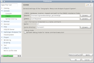
Just fill in the blank of the main options if they are not set by default:
NOTE: The GISBASE is the folder in which there is the GRASS installation and it is different from the operating system and the installation type the user has done. To better simplify the things this is the folder in which there are the two main GRASS installation folders bin and lib.
This is valid in case of the user has a valid GRASS installation, and mainly for linux and mac users. For windows users there is the included GRASS executable in the JGrass plugins. By default the field of GRASS options in the preferences panel is completed with the right path, if not here the user has to write the path of the folder, in the plugins, containing the grass installation. In general it is: ... pathtoJGrassinstallationfolder\plugins\eu.hydrologis.jgrass.grass_1.0.0\windows\grass\grass\.
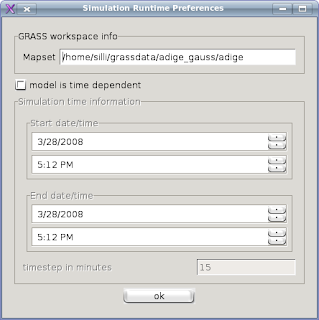
In addition at the windows preferences for the console the user has to set also the runtime Console preferences. The menu, shown below, is visible just right clicking on the console window and for GRASS commands the only important field is the MAPSET definition.
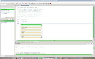
At this time the console environment is ready to use for GRASS commands. For example typing
Hope this helps the users in GRASS settings and command executing.
Hope also the develpers will not change this preferences again... :-) it will be not so exiting writing thousand post on the same topic... :-)
So from the last post in this field the options are less and the preferences are summarized in the following panel, as shown in the picture below.

Just fill in the blank of the main options if they are not set by default:
- MAPSET: the path of the mapset on which to work
- GRASS: the path to the GISBASE
NOTE: The GISBASE is the folder in which there is the GRASS installation and it is different from the operating system and the installation type the user has done. To better simplify the things this is the folder in which there are the two main GRASS installation folders bin and lib.
This is valid in case of the user has a valid GRASS installation, and mainly for linux and mac users. For windows users there is the included GRASS executable in the JGrass plugins. By default the field of GRASS options in the preferences panel is completed with the right path, if not here the user has to write the path of the folder, in the plugins, containing the grass installation. In general it is: ... pathtoJGrassinstallationfolder\plugins\eu.hydrologis.jgrass.grass_1.0.0\windows\grass\grass\.
In addition at the windows preferences for the console the user has to set also the runtime Console preferences. The menu, shown below, is visible just right clicking on the console window and for GRASS commands the only important field is the MAPSET definition.

At this time the console environment is ready to use for GRASS commands. For example typing
- grass r.info adige_pit
- grass r.in.gdal --help
- and so on...
- to run all the commands written in the console editor just right click and run
- to run only a selection of the written text, simply select the whole command to run and the right click and run
- it is possible to have some hinst form JGrass for writing the command, just wait a second after typing the "." in the commands names and after the "--" in the options.

Hope this helps the users in GRASS settings and command executing.
Hope also the develpers will not change this preferences again... :-) it will be not so exiting writing thousand post on the same topic... :-)
Subscribe to:
Posts (Atom)